Sunday, March 6, 2011

Works Cited

"Annual Days of Sunshine in California - Current Results." Current Results. Current Results Nexus. Web. 04 Mar. 2011. .

"Average Weather for Sacramento, CA." Weather.com. The Weather Channel, 28 Feb. 2011. Web. .

"California Biotechnology Foundation." California Biotechnology: Revolutionizing Global Healthcare. California Biotechnology Foundation. Web. 04 Mar. 2011. .

"California Food Facts - Production & Crops California." California Beaches | Vacation Travel Guide for Beaches in California. BeachCalifornia.com. Web. 13 Feb. 2011. .

"City of Sacramento - A Brief History of the City." City of Sacramento, California, USA - Municipal Government. City of Sacramento. Web. 30 Jan. 2011. .

"Hawaii QuickFacts from the US Census Bureau." State and County QuickFacts. US Census Bureau. Web. 06 Mar. 2011. .

"A Look at California's Agriculture." AG Classroom. Agriculture in the Classroom, July 2010. Web. 2 Feb. 2011. .

"Los Angeles County QuickFacts from the US Census Bureau." State and County QuickFacts. 4 Nov. 2010. Web. 03 Mar. 2011. .

"The Port of Los Angeles | About the Port." The Port of Los Angeles: America's Port. Port of Los Angeles. Web. 16 Feb. 2011. .

"Port of New Orleans Overview." Port of New Orleans - Louisiana, USA. Port of New Orleans, 21 Dec. 2009. Web. 16 Feb. 2011. .

"Sacramento, California City History and Historical Figures - ByCityLight.com." ByCityLight.com - Welcome to ByCityLight.com, Your Tour Guide To The Cities You Love. CityByLight.com. Web. 31 Jan. 2011. .

"Sacramento, California Climate, Temperature, Average Weather History, Rainfall/ Precipitation, Sunshine." World Weather and Climate Graphs, Average Climate Charts, Guide to Precipitation, Temperatures, Best, Friendly, Holiday Climate. Climatetemp.info, 25 Jan. 2011. Web. 31 Jan. 2011. .

"Sacramento, California Climate, Temperature, Average Weather History, Rainfall/ Precipitation, Sunshine." World Weather and Climate Graphs, Average Climate Charts, Guide to Precipitation, Temperatures, Best, Friendly, Holiday Climate. Climatetemp.info, 25 Jan. 2011. Web. 31 Jan. 2011. .

"Sacramento (city) QuickFacts from the US Census Bureau." State and County QuickFacts. United States Census Bureau, 8 July 2009. Web. 31 Jan. 2011. .

"Sacramento County QuickFacts from the US Census Bureau." State and County QuickFacts. United States Census Bureau, 4 Nov. 2010. Web. 03 Mar. 2011. .

"Sacramento: Economy - Major Industries and Commercial Activity." Stats about All US Cities - Real Estate, Relocation Info, House Prices, Home Value Estimator, Recent Sales, Cost of Living, Crime, Race, Income, Photos, Education, Maps, Weather, Houses, Schools, Neighborhoods, and More. City-data.com. Web. 02 Feb. 2011. .

"Sacramento: Geography and Climate." Stats about All US Cities - Real Estate, Relocation Info, House Prices, Home Value Estimator, Recent Sales, Cost of Living, Crime, Race, Income, Photos, Education, Maps, Weather, Houses, Schools, Neighborhoods, and More. City-data.com. Web. 30 Jan. 2011. .

Stodghill, Ron, and Amanda Bower. "Welcome to America's Most Diverse City - TIME." Breaking News, Analysis, Politics, Blogs, News Photos, Video, Tech Reviews - TIME.com. Time Magazine, 25 Aug. 2002. Web. 03 Mar. 2011. .

White, Deborah. "Profile of Cesar Chavez, Latino Champion of Civil Rights & Fairness." Liberal & Progressive Politics & Perspectives. About.com. Web. 10 Feb. 2011. .

Saturday, March 5, 2011

Hawaii

The diversity that flows through Hawaii is intense, to say the least. Hawaii's strange history, which led it ultimately into becoming a state, is filled with conquests, contracted foreign workers, and political powers which were overthrown continuous times in the battle to make these islands into the claimed land they are today. Surprisingly enough, the story behind Hawaii's migration patterns is similar with Sacramento's, and each area do share the same idea about diversity, through each area is diverse in its own way.

I wish I was one of those people sitting on the beach right now enjoying the day.

Hawaii did not start out as a diverse area. Around 1500 years ago, the Polynesians, a group of islanders whom live on the islands that surround Hawaii, discovered the land and claimed it as their own. Their population peaked to 300,000 on the islands until it was discovered by Captain Cook in 1778. The news about the discovery spread throughout Europe and North America, causing people to settle there. Soon, the French, British, and the United States all shared land throughout Hawaii. The French had a strong influence on the islands from 1820 to 1850, and Britain claimed the land as their own in 1843, until the plantations from the United States overthrew the government in 1893 with their larger numbers of people. During this time, America began to contract workers from Asian countries in order to keep up with the required labor force that was needed to work at the plantations. After these laborers had completed their work on these plantations, many of them decided to stay on the islands. As all of this was going on, the Polythesians began to slowly die out. It is believed that less than 10,000 Polythesians are still on the islands today.

Don't you wish you were here right now, instead of sitting somewhere looking at a computer screen?
(Source: http://www.allamericanpatriots.com/files/images/hawaii-surfers.jpg)

Needless to say, with all this activity going on, Hawaii became very diverse through European, Asian, and American influences. According to the US Census Bureau, the largest population percentage in Hawaii for one ethnic group are Asians, totaling 38.8%. The second largest are whites, who make up 30.1% of the population, with 25.1% who are not of Hispanic origin. This is followed by Native Hawaiians at 9.1%, Hispanics at 9.0%, Blacks at 3.2%, and Native Americans at 0.6%. 18.2% claim that they are of two or more races (census.gov.) With this type of diverse mix, it would be common to see inter-racial relationships occurring in many different fashions.

A happy diverse group of people within Hawaii. They're probably happy because they get to spend their time in such an amazing place.

Sacramento, on the other hand, has its own story on its diversity as well. According to city-data.com, Sacramento's history started around 10,000 years ago, where Indian tribes had established their living before any other settlers had arrived. In 1808, Spanish soldiers discovered the Sacramento and American rivers, and made some of these Indians their slaves. Many Indians had been taken as slaves by the Spanish. In 1839, John Sutter established a small town which he called New Heveltica. 11 years later, as the Spanish were being driven off of this land, the area would become Sacramento, and 4 years after this in 1854 the city would become the capital of California. The gold rush, which was occurring during this time, brought a rapid influx of people who came to "strike it rich" from overseas (citydata.com). During the late 19th century (and entering into the 20th century) immigrants from China began to filter into Sacramento in order to escape the wars which were occurring in their homeland, and as cheap laborers who came under contract to work here. Though they faced major discrimination by others, many Chinese immigrants decided to stay in Sacramento. Even through today, Sacramento continues to take in immigrants from Asia and other countries. Sacramento's diversity is well-known. It is so well known, that Time Magazine published an article in 2002 that called Sacramento the "most diverse city in America" (Stodghill).

These kids whom come from a variety of different races look happy in Sacramento, but could you imagine how much happier they'd be in Hawaii?

In either case, the diversity in both Sacramento and Hawaii has helped enhance these areas to be more welcoming to others, build better interracial relationships, and has created a more positive environment. People in these areas seem to be more open-minded about different topics and issues, which inspires development and creates a strong community among ethnically different people.


Now that I'm done with the majority of the work for this class, I'm going to Oahu. Now I just need some money...

Friday, March 4, 2011

The Pacific North Coast

The Pacific North Coast is known for its beautiful outdoor scenery and recreational potential. In fact, many Americans move to this region due to the fact that the outdoor life here is encouraged by most residents. Certain parts of California that do not fall within the Pacific North Coast region are also viewed in similar ways, though the connections between the two may be different.

View of the beach from a turnoff spot off highway 101 near Pacific City in Oregon. One of the pictures I took during my recent trip to Oregon in February this year.
(Source: My Camera!)

Each have their similarities and differences when it comes to the different recreational activities available within each region. The Pacific North Coast is famous for its various forested areas and campgrounds that surround (and are within) the cities. Areas in Oregon, such as Corvallis or Pacific City, are filled with different outdoor activities that can be enjoyed by everyone, such as the trail that runs through Bald Hill behind where Oregon State University is located, or the dunes on the Oregon coast that give a spectacular view of the Pacific Ocean and its jagged coastline. Similar areas are found within California as well in both the Northern and Southern portions of the city. Beaches, such as the ones in Carpenteria, have situated campgrounds where both whales and sea lions can be seen during particular times of the season, and trails such as the various ones that run through the dry portions of Santa Clarita can have spectacular views within the hills that overlook the surrounding valley.

This is the view over one of the larger dunes found in Pacific City, about 350 feet above the shoreline below.
(Source: My Camera!)

The differences, though small, are still noticeable enough to be discussed. For example, one outdoor activity that does not occur in the Pacific North Coast as much as it does within California is ocean surfing. Ocean surfing is more popular within the California coast due to the fact that the water is often quite warmer here than in the Pacific North Coast, and because California beaches are often not as rocky or dangerous, making it safer to surf in case of an incident. Areas in Southern California, such as Emerald Bay or Laguna Beach, are primary surf spots all throughout the year. Other differences include that people who live in California normally do not move there due to its outdoor recreational value like they do within the Pacific North Coast. Most people who move to California enjoy the views of the area and would much rather find a good spot to live where they can wake up to these views instead of actually going out to explore them. This is more difficult to do within the Pacific North Coast regions, due to the fact that most of the areas here that have such beautiful views are public land that cannot by law be privately owned, making it next to impossible to build any type of home there. An example of this can be seen down the Oregon coastline, where it is prohibited for an individual or company to own any portion of the beaches.

Warning: Some surfing is not for the faint of heart.
(Source: http://surfing-beach.com/wp-content/uploads/2010/08/california-surfing.jpg)

But if these two regions have more similarities than differences, then why is the population within the two regions so contrasting? This answer can be found when we look over the other differences between the two. People move to California for many other reasons, such as its abundance of different career opportunities, the ability to create a better life for one's family, it's dry and warm climate, and its welcoming diverse community. However, the Pacific North Coast has limited opportunities when compared to California, due to its hard to reach region which makes exporting goods difficult, its cooler climate which limits agricultural opportunities, and its homogeneous population which defeats the ability for diversity to occur. Simply put, the opportunities presented within the Pacific North Coast are overshadowed by the ones presented within California.

Picture taken along the Oregon coastline. The large rocks here are home to mussels and the starfish who eat them.
(Source: My Camera!)

Thursday, March 3, 2011

California

Although California is a state, many people see it as a country of its own. The state, which is the third largest in the US in size, houses approximately 12 percent of the entire US population, making it the most populated state in the country. However, California is known for more than just this amazing record.

The Official California Flag. I couldn't think of a good Dwight quote to put here about bears.
(Source: http://www.parks.ca.gov/pages/22491/images/california_state_flag.jpg)

California is also the number one agricultural provider within the United States. According to Agriculture in the Classroom, California grows more than 350 different crops per year, with many of them being solely grown within the State. These crops, which makes up over half of the nation's fruits, vegetables, and nuts, generate an estimated $36.2 billion every year in revenue and has made California the top agricultural state (AG Classroom). One reason why California is so strong agriculturally is due to the state's climate. The state enjoys 261 days of sunshine a year on average, according to the Current Results Nexus. The amount of sunshine varies throughout the state, giving the state both cool and warm environments and maximizing growth capabilities by allowing farmers to grow whichever crops they'd like. Another reason includes the concept behind specialty crops, where a farm will focus solely on growing one particular crop in order to maximize efficiency. California normally distributes the their crops the most during the wintertime to other states due to the fact that the weather that occurs in the rest of the United States give poor growing conditions.

Almond trees growing in California
(Source: http://musingbymoonlight.files.wordpress.com/2011/01/almondtrees.jpg)

California is also known for its revolutionary political views, which often differ from the rest of the country's beliefs. Items such as legalized same sex marriages, open border policy concepts, and legalized marijuana (as well as dispensaries located throughout the state that make it easy to obtain marijuana) are quite often not seen anywhere else, especially in more conservative states. The reason behind this lies in the diversity that creates California. Most of the northern and midwest portions of the United States stay very homogenous, which can also cause their views to become very similar with one another, and quite often single focused. Other factors, such as universal religious beliefs, also deeply impact individual's values. With factors like these, it becomes difficult for the people within these regions to understand the reasoning behind certain new laws and beliefs, mainly because they cannot view the concept from both sides (or actively refusing to.)

Pro same-sex marriage rally in San Francisco
(Source: http://www.csmonitor.com/var/ezflow_site/storage/images/media/images/2010/0124-weekly/0124-awedstrategy-san-francisco/7265824-1-eng-US/0124-AWEDSTRATEGY-san-francisco_full_600.jpg)

California is also known for being the leading state in a number of industries. One example of these industries can be seen within Southern California, which is the leading aircraft-manufacturing center in all of the United States. This is because many aircraft companies choose to have their planes developed within California (such as Boeing), or because the actual aircraft company is based in California, such as Lockheed Martin. Though this industry may be viewed as being a limited one, it is quite the opposite. Approximately 20 percent of the Department of Defense's budget is entered into California every year, which the majority of it goes to Lockheed Martin. This, plus half the federal budget for NASA, helps employ many of the 2.9 million people who currently live in San Diego today. Another leading industry within California that has recently become more popular is biotechnology. According to the California Biotechnology Foundation, the biotechnology industry was started in California, and has made California the home of over half the life saving medical therapies that have been approved by the FDA in the past 26 years. Biotechnology is the leading industry that is focused on curing "non-curable" diseases by altering the way DNA works (masonbay.com).

F-35 Joint Strikc Fighter Jet, developed by Lockheed Martin
(Source: http://www.aviationearth.com/Lockheed_F-35_Joint_Strike_Fighter.jpg)

In conclusion, it can be understood on why some people view California so differently from the rest of the United States, and why not everyone is comfortable with the way Californians live their lives. However, this change, though it may be daunting, should not be viewed as bad. As the old saying goes, "The only thing that never changes is change". Some of us just embrace change more than others.

Wednesday, March 2, 2011

The Southwest Border Area

The southwest border area, compared to other portions of the United States, has a style that is all its own. The ethnic cultures that flow through these areas make it unique, and can only be compared to the type of culture that is seen in places within the outskirts of Megaopolis, such as New York City. Around these areas, people live their lives a bit differently than the rest of the world, mainly due to their cultural backgrounds and beliefs that they have brought into their present day lives, either from their own families who have kept their cultures alive within the United States, or from others who are new to our country from Central and South American countries. We can see these clear differences when we compare Sacramento, a Northern California city, to Los Angeles, a Southern California city. Though only 365 miles separate the outer portions of each city to one another, the differences that we see between these two cities is phenomonal.

Where do you plan to go today?
(Source: http://farm3.static.flickr.com/2743/4349302703_e101171483_z.jpg)

For starters, we can see the comparisons between people by looking at the populations that are found within each county. According to the 2000 Census Bureau statistics for the county of Los Angeles, the county housed an estimated 9,848,011 residents, with 48% percent of those residents being Latino. The county of Sacramento housed an estimated 1,400,949 residents in 2009, with 20.5% of those residents being Latino (Census.gov). Both the larger population and the larger percentage of Latino's within Los Angeles contributes to its very consistent ethnic activity that can be see throughout the county. Whereas Sacramento is normally focused around being a city that is very unprovoked by just one culture, making it unbiased to any ethnicity.

Go ahead. Count how many cars there are.
(Source: http://philip.greenspun.com/images/pcd0222/los-angeles-traffic-44.4.jpg?)

These numbers make the difference on what to expect in each major county. In Los Angeles county, the Latino culture has its imprint on just about everything. Many billboards and advertisements come in both English and Spanish. More businesses and government jobs favor individuals whom are both fluent in both English and Spanish instead of just one. Certain items, such as specialty snacks like Pulparindo's (which consists of the dried pulp of a tamarind covered in sugar and chile salt) or bakery items such as pan dulce (sweet bread) are commonly found in the southwest border area, but are more rarely found elsewhere. Not all residents are expected to know English, which is acceptable here due to the mixture of the population, but would not be acceptable in areas such as the Great Plains or the Agricultural Core. Images of the Virgin Mary and Guadalupe are seen more often than in other places, due to the strong Catholic influence from Mexico, where Catholicism is the dominant religion. Latino's are proud of where they've come from, and who they are now. They widely show their roots throughout the county, and keep their culture thriving by bringing it into their daily lives.

Latino culture runs deep through Los Angeles
(Source: http://farm3.static.flickr.com/2631/4177317768_9e73d1524e.jpg)

However, a very different picture is shown in Sacramento. The county (and most namely the city) consists of a very mixed "melting pot" which prevents any particular ethnicity from becoming dominant. An article in Time magazine explains this phenomenon, they name Sacramento "America's most diverse city", explaining that the residents here have found multiple ways to blend in together without being biased or segregated. Multi-racial couples are common here, and transparency is seen both in classrooms and businesses, even through language barriers. The only common area where race still plays a role that separates people is within the church and through gang activities (Stodghill.) This kind of diversity allows Sacramento to run like a well maintained machine, and prevents issues such as hate crimes from occurring.

Diversity is seen normally through within any workplace in Sacramento.
(Source: http://www.sacda.org/assets/img/diversity/div3.jpg)

However, these characteristics do not make one area better than the other. Each county shares its strengths and weaknesses in their own ways, and its a matter of how an individual fits within these characteristics that allow them to fit within their environment. The cultures that we live within can only effect us as much as we'd like them to, and its our choice to either embrace our surroundings or dismiss them.

Why Can't We Be Friends?
(Source: http://pndblog.typepad.com/photos/uncategorized/2008/09/08/diversity_4.jpg)

Tuesday, March 1, 2011

The Empty Interior

Since the 19th century, America's fascination with gold and silver has brought individuals (and their families) out on quests in order to find lands where they could "strike it rich". Pathways to states where gold was abundant (such as the Oregon Trail) were quickly formed and traveled over, until the mining areas ran out of ore, to which they were abandoned and people moved onto the next one. States that are located within the empty interior such as Nevada became popular in this era for gold and silver mining, as well as other areas such as ones in Northern California around Sacramento.

Gold Ore found at Mother Lode, near Sacramento
(Source: http://nevada-outback-gems.com/prospect/gold_specimen/gold_ore_calif_b.jpg)

Throughout Nevada, gold mining was a very enticing reason for moving to the dry desolate desert. Miners began to populate the region even before it had become a unionized state, and came to live with the Mormons who had already established a settlement there. Towns and cities such as Virginia City began to spring up around areas where precious metals were discovered (namely gold and silver). However, the life of these cities was short-lived, due to the fact that these mines became quickly depleted due to their popularity, which caused people to move away from these towns to mine elsewhere, quickly transforming a once populated area into a ghost town. Nowadays, these areas have become tourist attractions.

Virginia City in the 1860's
(Source: http://nevada-outback-gems.com/Mark_Twain/virginia_city1861.jpg)

In Northern California, similar actions were taking place, but not quite in the same manner. Settlers from the East and Midwest began to trickle into both California and Oregon during the Gold Rush era of the 1850's. Northern California became famous for the gold mines that were found in places such as Eureka, and had more settlers established themselves there due to the large amount of mines that were found in the area. Some of these towns, such as Bodie, were filled with people during this era, but became ghost towns once the mines near the towns ran out of gold. However, some of these cities did survive long enough to be the major ones that we see today. One example of this is Sacramento. When John Sutter was building the foundation for his mill, he discovered gold around the area. After word had gotten out about the gold, settlers began to rush into his town and area, hoping to strike it rich there. His son, John Sutter Jr., was able to take these settlers and grow Sutterville into modern-day Sacramento, which became the state capital in 1854. Though the gold around Sacramento is very much depleted from how much there once was, the city is still very active, with just under 1.4 million residents.

Sacramento River in 1860
(Source: http://content.cdlib.org/ark:/13030/kt696nc58z/hi-res%3Bjsessionid=DvS-cWFCvv-PIveM)

If we were to review both Virginia City and Sacramento together, and focus on the strengths and weaknesses of each, we can see that Sacramento has a lot more potential than Virginia City ever had. For starters, Virginia City is located in a very desolate area, where there is little to no vegetation and water. The city was not very close to any major rivers, which prevented water from being irrigated to the city without having to pay for substantial work to be done in the area. The city was not close to any substantial transportation hubs, making it costly to ship goods to and from the city, and making it hard to travel to the city except by horseback, wagon, or on food.

Virgina City In Present Day
(Source: http://www.desertusa.com/Cities/nv/photos/DSCN0905.jpg)

However, Sacramento was (and still is) quite the opposite. Sacramento's location between the Sacramento and American rivers made it easy to ship goods in and out of the city to other areas, and also made it popular for exporting goods to other countries. Due to the city's easy shipping routes, many railroad companies turned Sacramento into a railroad hub, where today the US's largest railroad company in the country is located. The area around Sacramento is filled with plush vegetation, where many farms are located with distribution centers and canneries based in Sacramento. These opportunities have allowed Sacramento to stay prosperous and active area within the United States.

Sacramento in Present Day
(Source: http://www.planetware.com/i/photo/sacramento-ca339.jpg)

Monday, February 28, 2011

The Great Plains and Praries

The Great Plains region, upon first glance, does not seem to have anything that stands out as "great" within it. The land appears flat when its driven through, it's land lacks nutrients and therefore is not very useful for growing many crops, and the land is mainly agricultural based, focused on growing wheat and tending to livestock. However, what I believe makes this area so great, is the weather that the region experiences every year. From very hot summers to frigid cold winters, this region has some of the most spectacular weather patterns seen all across the US. When comparing the weather in Sacramento to the weather in the Great Plains, one can argue that the weather in Sacramento is much nicer than in the Great Plains. However, when it comes to the sheer forces of nature in the two regions, Sacramento can't even compare to what is seen in the Great Plains.

Just another sunny day in Sacramento
(Source: http://northerncaliforniahikingtrails.com/blog/wp-content/uploads/2008/08/sacramento-river-rafting.jpg)


For starters, the temperature in Sacramento throughout the year is pretty predictable and does not often have the ability to change rapidly. According to The Weather Channel, the average high temperature in Sacramento is 94 degrees Fahrenheit in July, and the average low temperature is 40 degrees Fahrenheit in December. The record high in Sacramento is 114 degrees Fahrenheit, and the record low is 14 degrees Fahrenheit. (Weather.com) This shows us that the average temperatures in Sacramento have a range of 54 degrees, which is quite mild compared to other places around the country. Even when comparing the record highs and lows, there is only a 100 degree difference between the two. However, when reviewing the temperatures in the Great Plains, there is no doubt that they have worse weather than we do. Due to the rapid climb in Latitude from the top of the Great Plains in Canada, all the way down to Texas, it's hard to give an exact average temperature that is able to work with the entire region. However, what can be noted is the extreme temperatures that are seen in the upper and lower portions of the region. In the Southern region within Texas and in the Northern region within North Dakota, temperatures as high as 121 degrees Fahrenheit have been reported in each place. North Dakota also has the record lowest temperature within the region as well, with the area dropping to be as cold as -60 degrees Fahrenheit. When solely viewing the range of extreme high and low temperatures in North Dakota, we can see that there is a range that is between 181 degrees in this state alone, which bears the biggest example of extreme temperatures in this region.

Go ahead, enjoy the snow. I'll stay nice and warm over here.
(Source: http://druidnetwork.org/files/namerica/nplains_winter.jpg)


Precipitation levels between Sacramento and the Great Plains vary as well. According to The Weather Channel, the average rainfall per year in Sacramento is 19.37 inches, with the highest amount of rainfall occurring in January, and the lowest amount occurring in June through August. In the Great Plains, these numbers very based on the location and year. In some areas in the Southeast, the average rainfall is 42 inches per year, while the Southeast only gets an average of 16 inches per year. Other factors, such as the severe droughts that occur in the area, also affect these averages, and can cause considerable issues to the crops that grow within the area. It is also important to note that the rainfall in the Great Plains normally occurs mainly from April to August, which is vastly different than the rainfall patterns seen in Sacramento.

Looks like it rained a little too much in Kansas...
(Source: http://www.kswestumc.org/console/files/oPictures_Pages_HSBCSF/KansasEastFarm_JM_7ZUUGUXY.jpg)


However, what is probably the most noticeable difference (and the most spectacular one) is the difference in extreme weather that occurs within each region. Sacramento's weather per year does not have too many noticeable changes. Normally, the only noticeable change that can occur is some added rainfall and thunderstorms in some years more than others, slightly higher chances of hail and sometimes even snow. During most years, high winds will pick up in the summertime throughout the city, which adds onto the already dry conditions due to the hot weather. The Great Plains, however, has an entirely different set of extreme weather patterns that occur throughout the region. Weather such as heavy thunderstorms and strong winds are common throughout the Great Plains every year, due to the fact that air masses do not run into much resistance until they enter the region. Hail is also very common throughout the area, and can sometime reach sizes that are bigger than 3-4 inches. However, probably the most spectacular weather that occurs in this area would have to be the tornadoes which form here during the spring and early summer. The Great Plains suffers from more tornadoes per year than any other region in the United States, which gives the region the famous name of being the "Tornado Alley" of North America. Other extreme weather in this area includes blizzards, which are known to kill both crops and livestock thanks to the amount of snow that falls in the area within such a short time.

Take cover. Now.
(Source: http://media-files.gather.com/images/d78/d356/d746/d224/d96/f3/full.jpg)


In conclusion, these two areas differ greatly in the types of weather that are seen in each area. After reviewing the extreme temperature and weather conditions that occur in the Great Plains, it's no wonder why so many people end up leaving their region to settle in places such as Sacramento and other portions of California instead.

Tuesday, February 22, 2011

The Agricultural Core


Due to the number of agricultural products that are grown in California, its easy to see how the agricultural core and California would have at least this in common with one another. The major crops that are grown in each area, however, do differ from one another.

An older farm found in the Midwest
(Source: http://api.ning.com/files/3jbIggEaFtYEzhfO0OEkYvJOWMPY*U4BVCwBnUWD3LkNfefHweBLrw*DsIg-uCqU3BVWQkts-UU31GVMtfO2-tTDlY2SZ*uc/DechowFarm.jpg)


Within the Agricultural Core, there are three main crops that are found to be grown throughout the region: corn, soybeans, and wheat. The majority of corn is grown in Iowa, while the second largest majority can be found in Illinois, then Kansas. According to Britannica.com, The area where corn is mainly found is known as the Corn Belt, which goes through Indiana, Illinois, Iowa, Missouri, Nebraska, and Kansas (Britannica.com). Soybeans, the next main crop, have only recently become a hot seller within the agricultural market. In 1925, this crop only had 200,000 hectares harvested in the entire United States. In 2002, the midwest alone grew over 10 million hectares of soybeans, making the majority of the 16.1 million hectares of soybeans that were grown in the entire United States. These soybean crops have replaced many corn crops within the agricultural core, due to the fact that soybean crops have the ability to replenish the soil from which they grow with nitrogen, and the turnaround time between growing crops of soybeans is only 2 years, compared to the 3 years it takes for corn. Many soybean crops can be found growing within the Corn Belt as well. The last main crop, wheat, is found in non-forest filled areas where grass is more commonly found. Many wheat farms are found close to the waterways within the agricultural core due to the easy transportation that was available over the water.


A common crop of corn found in the Agricultural Core
(Source: http://images.gizmag.com/hero/corninsecticide.jpg)

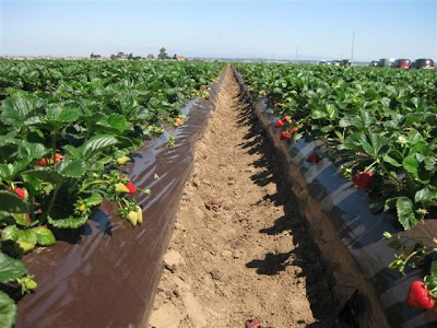
The three biggest crops that are grown within the state of California are strawberries, grapes, and almonds, according to the California Department of Food and Agriculture. The entire gross of strawberries that were grown in California last year weighed over 2.4 billion pounds, and was responsible for over $1.7 billion dollars in value (CDFA). Many of these berries are transported across the country during the winter seasons to other states, due to the fact that most states cannot grow strawberries during the wintertime. During the summertime, strawberries are mainly grown in both southern and northern California, with many of them being canned in Northern cities (such as Sacramento, which has one of the largest cannery distribution centers in California.) Grapes yield an even bigger crop, with an estimated 6.5 million tons grown in California in 2009, which was valued to be worth over $3.2 billion dollars (CDFA). According to the Columbia Encyclopedia, Grapes are one of the crops that are mainly grown in California, with the state supply around 2/3rd's of the country's supply per year (Columbia Encyclopedia). In California, these grapes are mainly exported to other states. However, in parts of Northern California (especially within the Napa Valley), grapes are turned into wine through multiple wineries that are scattered throughout the area. The last major crop that is grown in California is almonds, which yielded 1.4 million tons in 2009 and was valued at almost $2.3 billion dollars (CDFA). Almonds are almost exclusively grown in California, with 99 percent of Almond crops being within the state. Almonds are normally canned and distributed throughout the country both as snack products and cooking products.

Strawberry crops found in California
(Source: https://blogger.googleusercontent.com/img/b/R29vZ2xl/AVvXsEiPf5wycijc2MZWA9sRdsu9Vil7CAxU7YUu5NJByN1L79UJVKyqCIpo7c1TRZ_6Xv0hyphenhyphen5J8GGZx9wRo6cm7RrtfD9oCtb62f86phjnbe2bmO2V179A8Bv04WOcqQ_gy3p1GDmeNYF5FT3BY/s400/Strawberries+5-8-09+006.JPG)

Friday, February 11, 2011

The Southern Coastlands

The coastline in Miami, FL
(Source: http://www.visitusa.com/florida/images/miamipic.jpg)

The Southern coastlands provide a variety of similarities that one could experience in California. However, when comparing the two, the small differences within the similarities are quite surprising, when you think about it.

The Pacific Coastline in California
(Source: http://www.treehugger.com/california-coastline.jpg)

For starters, the climate in the two regions are very similar to one another. Throughout the year, both the Pacific and Southern coastland regions experience warm weather year-round, which is ideal for growing various types of fruits and vegetables. Citrus fruits are the mainly grown crop in the South, while California's biggest crop is Strawberries. Both regions are responsible for growing foods that are exclusive to their regions, as well. According to a leading site on facts about California, the state exclusively grows produce such as "almonds, artichokes, dates, figs, kiwifruit, olives, persimmons, pistachios, prunes, raisins, clovers, and walnuts." (BeachCalifornia.com) The Southern Coastlands do not have any produce that is grown exclusively in the region, but do have specialty crops that are grown in the region. Some of these crops include sugarcane, which can only be grown in a tropical environment (and therefore do not have the ability to be grown in California), rice which helps feed the majority of the midwest and east coasts, and items that can only be grown in very sunny conditions, such as avocados and cucumbers.

Avocado trees in California
(Source: http://lh3.ggpht.com/_cH-zOpvDDF8/RniJxmaAOVI/AAAAAAAAACw/6JcXCKteDhw/Temecula-+Day+1+023.JPG)

However, though both climates do have warm weather, the type of climate is different in both areas. The Southern Coastlands enjoy warm but humid weather year-round, making it easier to grow more tropical produce such as sugarcane, which requires a humid climate in order to grow properly. The humidity in these areas can reach 90-100 for the majority of the year. The rainfall for these areas generally exceeds 50 inches per year, with rain falling year-round. However, in the lower Pacific climates where California is located, the area is generally both warm and dry. The annual average rainfall in California is 22 inches throughout the state, making it the 40th wettest state in the United States. The rainfall here normally only occurs during the fall, winter, and spring, and rarely occurs during the summer. Because the amount of rainfall per year is so low, the area is mostly hot and dry, especially during the summertime.

Map of rainfall that occurs in the Southern Coastland region
(Source: http://coaps.fsu.edu/climate_center/specials/images/flheavyrain/map1.png)

The next comparison that we can make is between the amount of trade that goes through the Southern Coastlands versus the trade that goes through California as a whole. Thanks to the placement of the Southern Coastlands, combined with the natural canal to the Mississippi River through New Orleans to the states in the Midwest, this area is a large transport connection between the southern states and northern states, as well as a connection between the United States and the rest of the world. The Port of New Orleans, for example, is one of the largest ports in the entire world, moving over 500 million tons of cargo each year, according to the Port of New Orleans website (portno.com). California, however, has its own large ports as well, with one of the world's largest being stationed in Los Angeles. According to the Port of Los Angeles website, the port has been number one for decades in container throughput in the country, and employs over 1 million people (portoflosangeles.org)

Port of New Orleans
(Source: http://lh3.ggpht.com/_MV3XaiIYwTw/SXuWQXTC3bI/AAAAAAAACm0/ywxr7j-pTXc/IMG_2244.JPG)


However, the way that these two ports transfer their goods varies. The majority of shipments that come through the Southern Coastlands are shipped up the Mississippi River to other states, thanks to the fact that the Mississippi River is one of the easier way to ship goods to the midwest. This, combined with the railroad lines that run through the area, make it easy to ship items to anywhere in the United States. However, the Port of Los Angeles has only limited access to nearby North American cities, since it does not have a natural river that runs through the nation like the Mississippi. Therefore, it must rely on ground transportation such as railroads and large trucks in order to get shipments from one side of the country to the other.

Tuesday, February 8, 2011

The Changing South

Throughout the South starting in the early 17th century and ending during the 19th century, enslaving both Blacks and Indians had been a common activity performed by Whites. The first African slaves landed in the Southern United States portion of North America in 1619, and the first Indians were captured and enslaved in the late 18th Century. These slaves were first forced to work on early plantations, which started to appear in 1612. The use of these slaves rapidly increased during both the 18th and 19th century, though most American Indians were forcibly removed from the South by the 1830's (making the majority of slaves left only Blacks).

Native Americans in the South
(Source: http://cdn.dipity.com/uploads/events/59b8f46f028d05695f0a9c2a9ce23354_1M.png)


After the Civil War ended in 1865, every slave that had been forced to work on any farm or plantation had been considered a free man. However, the Southern states, whom were full of residents who were upset about the new federal laws, began to come together to develop new state and local laws that segregated Blacks and Whites away from one another. Though these laws were supposed to keep conditions equal between blacks and whites, in almost all of the south these laws always favored Whites over Blacks, which slowed the progression of Blacks in becoming successful in the South.

One of many separated public water fountains in the South.
(Source: https://blogger.googleusercontent.com/img/b/R29vZ2xl/AVvXsEhCbRNiEK-0T28_L6wlAr42u7KTSJziXvxFlKTNJrQB-nSWLj1YVGJBPxDRGoiHg651ARppESScW9JeptTbpvLLSFm-FvnXUv7yD-tLQIVyA4FGD32CblcvcJGTDAi0LCEPnRcmd_wcJIaY/s1600/30s+parks+segregation.jpg)


Other issues emerged as well, such as the combined poverty that both Blacks and Whites were suffering from at the end of the Civil War. Though Blacks were technically now free, none of them had any land or money for themselves, leaving them incapable of taking care of themselves or their families. Most Whites, though now poor and suffering from the damages that had occurred to their land during the Civil War, still had the land that they had previously owned before the war, and therefore had the ability to grow their crops again. From this, the concept behind sharecropping was born. Sharecropping allowed Blacks to grow their own crops on a part of a plantation owner's land, and keep part of the procceds that came from those crops. However, in return, they had to share a certain portion of that crop with the plantation owner, and pay the plantation owner for the use of their tools, rent... etc, as well. This system often caused Blacks to go into debt with the plantation owners, forcing them to work on the land to pay off the debt (which they could almost never do.) Eventually, as different industries began to enter into the South that offered job opportunities which gave more benefits and empowered poorer individuals more than their current jobs, as well as the slow but steady migration of Blacks into the North stopped this legal version of slavery from occurring.

Family that moved to Chicago for work in the early 20th Century
(Source: http://discoverblackheritage.com/wp-content/uploads/2007/12/great-migration-chicago.jpg)

However, even though it did not occur in the same ways in California, it can be argued that the same type of issues arose in the state as well, with some of this activity occurring in the area where Sacramento is currently located. For starters, the area that was to become Sacramento back in 1840 when it was first established by John Sutter was originally built by Indians whom had become slaves under Sutter. These slaves built Sutter's Fort, which still stands today in the middle of Sacramento. However, when the Civil War started in 1861, the State of California sided with the North instead of the South, showing that they did not support the South's ways.

Painting of Sutter's Fort before restoration
(Source: http://www.usgwarchives.net/ca/sacramento/postcards/sfort2.jpg)

Though it wasn't the same method as sharecropping, there was a trend that was occurring in California in the late 19th/early 20th century that was similar to the idea of sharecropping. Thousands of migrant Latino farm workers during this time were being underpaid and overworked by their employers, and were forced to live in dirty one room tents and shacks. The corporations whom owned the the land were keeping the majority of the profits that these produce items made, even after multiple farm workers complained to the corporations about their low wages. However, the number of workers looking for jobs was always high, so it never mattered to a corporation if they lost a farm worker, since there would be one available to replace the worker whom quit. These workers (as well as many other Latino individuals) were also segregated by Whites in some portions of California in the same ways that Blacks were segregated in the South. Though what was being performed here was not exactly the same to what was occurring in the South, the two were similar in the fact that the owners behind each plantation or corporation were actively exploiting their workers by underpaying them and forcing them to live in unfair conditions.

Restaurant which supported segregation in California
(Source: https://blogger.googleusercontent.com/img/b/R29vZ2xl/AVvXsEh9UxPHw2wKKv9GFYIqqSQPnyyg9itFOowMYdVo-zmqX-coiiEVDL-a_3ze-mP8b4-Ih02oZZDQSCz1y0dJjxnd0qtmKgmr7_KGbGCYUVtrbTfJbhUIqBKimaxyArWD0CPyAx90ztfHpw/s1600/WhitesOnly.gif)

However, the revolution that came to change this in California began to occur in the middle of the 20th century by a man named Cesar Chavez. According to an Article on About.com, in 1962 Cesar Chavez formed the United Farm Workers union, which focused on the rights for farm workers in California. Cesar Chavez taught these workers about how unions work, and helped them use their power as a union to increase their wages and working conditions through boycotts and strikes (About.com). Through the power of the United Farm Workers, Cesar Chavez was able to stop the exploitation of farm workers throughout California, enact laws which protected farm workers, and revolutionized the way California agriculture businesses are run today.

Image of Cesar Chavez giving a speech to United Farm Workers members
(Source: http://www.freedomarchives.org/images/Cesar_Chavez.jpg)

Friday, February 4, 2011

Appalachia and the Ozarks

Much like the bypassed east, the Appalachian Mountains and the Ozark region do not have much in common with the Pacific region where Sacramento lies. These two areas, located on opposite ends of the United States, are known for completely different attributes from one another.

For starter's, we can take a look at what each region exports. The Pacific's largest export in California (as mentioned in multiple previous posts) is agricultural goods, which constitute over half of the United States' food supply. The year-round warm and sunny climate makes it easy to grow food here, with help from the rich soil as well. The Appalachian's largest export is coal, which is mined from the surface's of the Appalachian Mountains in different states in the region, such as West Virginia and Pennsylvania. This coal is used not only in the United States, but is also exported to countries such as Canada, Japan, Brazil, and France. In the United States, coal is mainly used for generating electrical power, due to its low cost when compared to oil, and its safety factors when compared to nuclear power. Therefore, massive amounts of coal are needed to be supplied in order to generate power at these plants. The coal in this region is mined mainly in one of two ways: the first method is through underground mining, while the second method is through surface mining techniques.

Surface Mining for Coal
(Source: https://blogger.googleusercontent.com/img/b/R29vZ2xl/AVvXsEgScAfvTzi64VjhZhlTRaQbDm-OpmPAbmhaF6a2yM5ITT4lEAJ5vzd4kVCi6ZoCzMrravVUiHcpzj6A7xvTVUR6NfcYTeUb_ORCeFXeyIU52EPJFgFggEaqoF8Q1CYMyjJm-OEUYWQHiwzq/s1600/Strip_coal_mining.jpg)

The next comparison is the diversity between the two areas. According to information from the 2000 Census, the State of California is composed of over 22 million white citizens, with the second largest being listed as "Other". However, it is important to note that people of Hispanic origin have always been placed under as either "White" or "Other", due to the fact that up until this last census in 2010, there has been no choice available for "Hispanic" origin. However, when one visits any major city in California, it is easy to tell that these areas mostly are made up of either Hispanic or White people, with no majority being within the two. This is different from how the Appalachian and Ozark region is composed. The majority of Americans there have a European background. These backgrounds include people from Ireland, Scotland, Germany, and England.

Appalachian deep coal miners.
(Source: http://www.dailyyonder.com/files/imagecache/story_default/imagefield/Corn_Jack065.jpg)

The last comparison is with the topography that is found in each region. The Pacific region is composed mountainous regions, with a mix of smaller hills in between as well. Generally, the more North you go in the Pacific region, the more mountainous terrain you encounter. However, most of this terrain (especially in the northern region) is located next to the Pacific Ocean. The rest of the region, until you begin to get into Oregon, is mainly flat with some minor hills. The topography located in the Appalachians is, for the most part, mountainous and rigid everywhere. Intensive erosion has occurred in the region over millions of years here, through both intensive ice formations and rainfall occurring over the area. The small amount of agriculture that is grown here is grown within the valleys of the region, where a lot of smaller towns and cities are also located. River's that run through the valley have been known in the past to overflow and cause flooding. These rivers have been now equipped with dams, which both help stop flooding and generate power for the cities and towns that run through this region.

Appalachian Mountains in West Virginia
(Source: http://www.marietta.edu/~biol/biomes/images/alpine/mtopview.jpg)

Regardless of whether or not you choose one region over the other, both are beautiful in their own ways.

Wednesday, February 2, 2011

The Bypassed East


When comparing the bypassed east to the Pacific valleys of Sacramento, the two could not be more polar opposites. Here are some ways that the two are different from one another.

For starters, the climates within the two regions are very different. The bypassed east region has weather thats quite more often than not cold, damp, and rarely is hot. The areas of water that are around the region are never warm, which makes the area unpopular even in the summertime. The sky in the area is overcast and foggy all year long, making it near impossible to grow any plants that require sunlight. Snowfall is common during the wintertime throughout the region as well.

Brrrrrrrrrrrrrr...
(Source: http://www.winterwanderland.com/wp-content/uploads/2008/01/snowy-mill-creek-winter.jpg)

However, Sacramento is completely different. The climate in Sacramento has weather that is normally warm and dry, and can get hot during the summertime. In the winter, it is often rainy and rarely snows. The area only gets foggy during the winter and spring times, but is commonly warm and dry during the fall and winter. Though Sacramento does not have any beaches, people often swim and drive recreational boats in both the Sacramento and American rivers that go through the city.

Ahhhhhhhh... Much better!
(Source: http://media-cdn.tripadvisor.com/media/photo-s/01/1a/5a/8c/sacramento.jpg)

Another difference can be found in the amount of agriculture that occurs in each area. Most areas in the bypassed east are single-crop production areas, meaning that they only specialize in growing one particular item. One of the most popular crops in the regions are the wild blueberries, which grow successfully here due to the acidic soil in the area. Others include apples, tea, wheat, corn, and potatoes. However, the areas surrounding Sacramento are responsible for growing a majority of the produce that is enjoyed throughout the country, with over 350 different crops. Unlike the bypassed east, these crops are often packaged and distributed across the United States, thanks to both cheap and easy transportation access (which the bypassed east lacks.)

Mmmmmm... Blueberries. These picture captions are filled with just noises, I know.
(Source: http://urbangardencasual.com/wp-content/uploads/blueberries.jpg)


Though the two regions do still have many differences, it does not mean that each do not share similarities as well. One similarity between both regions is the abundance of oil that can be found in each one. In the bypassed east, multiple offshore petroleum reserves are found by the rich fishing banks in the area. In fact, the world's largest oil drilling platform is found here. California also has an abundance of oil in its region as well, though not nearly as big as in the bypassed east, and is mainly surrounded by both the central and southern California areas. Oil in California is accumulated by small onshore oil rigs, which can often be seen off the I-5 when travelling between Los Angeles and Sacramento or San Francisco.

Nibernia Oil Drilling Station... Lets hope that BP doesn't own this rig
(Source: http://www.heritage.nf.ca/society/images/hibernia1_600.jpg)