Monday, February 28, 2011

The Great Plains and Praries

The Great Plains region, upon first glance, does not seem to have anything that stands out as "great" within it. The land appears flat when its driven through, it's land lacks nutrients and therefore is not very useful for growing many crops, and the land is mainly agricultural based, focused on growing wheat and tending to livestock. However, what I believe makes this area so great, is the weather that the region experiences every year. From very hot summers to frigid cold winters, this region has some of the most spectacular weather patterns seen all across the US. When comparing the weather in Sacramento to the weather in the Great Plains, one can argue that the weather in Sacramento is much nicer than in the Great Plains. However, when it comes to the sheer forces of nature in the two regions, Sacramento can't even compare to what is seen in the Great Plains.

Just another sunny day in Sacramento
(Source: http://northerncaliforniahikingtrails.com/blog/wp-content/uploads/2008/08/sacramento-river-rafting.jpg)


For starters, the temperature in Sacramento throughout the year is pretty predictable and does not often have the ability to change rapidly. According to The Weather Channel, the average high temperature in Sacramento is 94 degrees Fahrenheit in July, and the average low temperature is 40 degrees Fahrenheit in December. The record high in Sacramento is 114 degrees Fahrenheit, and the record low is 14 degrees Fahrenheit. (Weather.com) This shows us that the average temperatures in Sacramento have a range of 54 degrees, which is quite mild compared to other places around the country. Even when comparing the record highs and lows, there is only a 100 degree difference between the two. However, when reviewing the temperatures in the Great Plains, there is no doubt that they have worse weather than we do. Due to the rapid climb in Latitude from the top of the Great Plains in Canada, all the way down to Texas, it's hard to give an exact average temperature that is able to work with the entire region. However, what can be noted is the extreme temperatures that are seen in the upper and lower portions of the region. In the Southern region within Texas and in the Northern region within North Dakota, temperatures as high as 121 degrees Fahrenheit have been reported in each place. North Dakota also has the record lowest temperature within the region as well, with the area dropping to be as cold as -60 degrees Fahrenheit. When solely viewing the range of extreme high and low temperatures in North Dakota, we can see that there is a range that is between 181 degrees in this state alone, which bears the biggest example of extreme temperatures in this region.

Go ahead, enjoy the snow. I'll stay nice and warm over here.
(Source: http://druidnetwork.org/files/namerica/nplains_winter.jpg)


Precipitation levels between Sacramento and the Great Plains vary as well. According to The Weather Channel, the average rainfall per year in Sacramento is 19.37 inches, with the highest amount of rainfall occurring in January, and the lowest amount occurring in June through August. In the Great Plains, these numbers very based on the location and year. In some areas in the Southeast, the average rainfall is 42 inches per year, while the Southeast only gets an average of 16 inches per year. Other factors, such as the severe droughts that occur in the area, also affect these averages, and can cause considerable issues to the crops that grow within the area. It is also important to note that the rainfall in the Great Plains normally occurs mainly from April to August, which is vastly different than the rainfall patterns seen in Sacramento.

Looks like it rained a little too much in Kansas...
(Source: http://www.kswestumc.org/console/files/oPictures_Pages_HSBCSF/KansasEastFarm_JM_7ZUUGUXY.jpg)


However, what is probably the most noticeable difference (and the most spectacular one) is the difference in extreme weather that occurs within each region. Sacramento's weather per year does not have too many noticeable changes. Normally, the only noticeable change that can occur is some added rainfall and thunderstorms in some years more than others, slightly higher chances of hail and sometimes even snow. During most years, high winds will pick up in the summertime throughout the city, which adds onto the already dry conditions due to the hot weather. The Great Plains, however, has an entirely different set of extreme weather patterns that occur throughout the region. Weather such as heavy thunderstorms and strong winds are common throughout the Great Plains every year, due to the fact that air masses do not run into much resistance until they enter the region. Hail is also very common throughout the area, and can sometime reach sizes that are bigger than 3-4 inches. However, probably the most spectacular weather that occurs in this area would have to be the tornadoes which form here during the spring and early summer. The Great Plains suffers from more tornadoes per year than any other region in the United States, which gives the region the famous name of being the "Tornado Alley" of North America. Other extreme weather in this area includes blizzards, which are known to kill both crops and livestock thanks to the amount of snow that falls in the area within such a short time.

Take cover. Now.
(Source: http://media-files.gather.com/images/d78/d356/d746/d224/d96/f3/full.jpg)


In conclusion, these two areas differ greatly in the types of weather that are seen in each area. After reviewing the extreme temperature and weather conditions that occur in the Great Plains, it's no wonder why so many people end up leaving their region to settle in places such as Sacramento and other portions of California instead.
Tuesday, February 22, 2011

The Agricultural Core


Due to the number of agricultural products that are grown in California, its easy to see how the agricultural core and California would have at least this in common with one another. The major crops that are grown in each area, however, do differ from one another.

An older farm found in the Midwest
(Source: http://api.ning.com/files/3jbIggEaFtYEzhfO0OEkYvJOWMPY*U4BVCwBnUWD3LkNfefHweBLrw*DsIg-uCqU3BVWQkts-UU31GVMtfO2-tTDlY2SZ*uc/DechowFarm.jpg)


Within the Agricultural Core, there are three main crops that are found to be grown throughout the region: corn, soybeans, and wheat. The majority of corn is grown in Iowa, while the second largest majority can be found in Illinois, then Kansas. According to Britannica.com, The area where corn is mainly found is known as the Corn Belt, which goes through Indiana, Illinois, Iowa, Missouri, Nebraska, and Kansas (Britannica.com). Soybeans, the next main crop, have only recently become a hot seller within the agricultural market. In 1925, this crop only had 200,000 hectares harvested in the entire United States. In 2002, the midwest alone grew over 10 million hectares of soybeans, making the majority of the 16.1 million hectares of soybeans that were grown in the entire United States. These soybean crops have replaced many corn crops within the agricultural core, due to the fact that soybean crops have the ability to replenish the soil from which they grow with nitrogen, and the turnaround time between growing crops of soybeans is only 2 years, compared to the 3 years it takes for corn. Many soybean crops can be found growing within the Corn Belt as well. The last main crop, wheat, is found in non-forest filled areas where grass is more commonly found. Many wheat farms are found close to the waterways within the agricultural core due to the easy transportation that was available over the water.


A common crop of corn found in the Agricultural Core
(Source: http://images.gizmag.com/hero/corninsecticide.jpg)

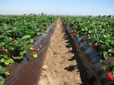
The three biggest crops that are grown within the state of California are strawberries, grapes, and almonds, according to the California Department of Food and Agriculture. The entire gross of strawberries that were grown in California last year weighed over 2.4 billion pounds, and was responsible for over $1.7 billion dollars in value (CDFA). Many of these berries are transported across the country during the winter seasons to other states, due to the fact that most states cannot grow strawberries during the wintertime. During the summertime, strawberries are mainly grown in both southern and northern California, with many of them being canned in Northern cities (such as Sacramento, which has one of the largest cannery distribution centers in California.) Grapes yield an even bigger crop, with an estimated 6.5 million tons grown in California in 2009, which was valued to be worth over $3.2 billion dollars (CDFA). According to the Columbia Encyclopedia, Grapes are one of the crops that are mainly grown in California, with the state supply around 2/3rd's of the country's supply per year (Columbia Encyclopedia). In California, these grapes are mainly exported to other states. However, in parts of Northern California (especially within the Napa Valley), grapes are turned into wine through multiple wineries that are scattered throughout the area. The last major crop that is grown in California is almonds, which yielded 1.4 million tons in 2009 and was valued at almost $2.3 billion dollars (CDFA). Almonds are almost exclusively grown in California, with 99 percent of Almond crops being within the state. Almonds are normally canned and distributed throughout the country both as snack products and cooking products.

Strawberry crops found in California
(Source: https://blogger.googleusercontent.com/img/b/R29vZ2xl/AVvXsEiPf5wycijc2MZWA9sRdsu9Vil7CAxU7YUu5NJByN1L79UJVKyqCIpo7c1TRZ_6Xv0hyphenhyphen5J8GGZx9wRo6cm7RrtfD9oCtb62f86phjnbe2bmO2V179A8Bv04WOcqQ_gy3p1GDmeNYF5FT3BY/s400/Strawberries+5-8-09+006.JPG)

Friday, February 11, 2011

The Southern Coastlands

The coastline in Miami, FL
(Source: http://www.visitusa.com/florida/images/miamipic.jpg)

The Southern coastlands provide a variety of similarities that one could experience in California. However, when comparing the two, the small differences within the similarities are quite surprising, when you think about it.

The Pacific Coastline in California
(Source: http://www.treehugger.com/california-coastline.jpg)

For starters, the climate in the two regions are very similar to one another. Throughout the year, both the Pacific and Southern coastland regions experience warm weather year-round, which is ideal for growing various types of fruits and vegetables. Citrus fruits are the mainly grown crop in the South, while California's biggest crop is Strawberries. Both regions are responsible for growing foods that are exclusive to their regions, as well. According to a leading site on facts about California, the state exclusively grows produce such as "almonds, artichokes, dates, figs, kiwifruit, olives, persimmons, pistachios, prunes, raisins, clovers, and walnuts." (BeachCalifornia.com) The Southern Coastlands do not have any produce that is grown exclusively in the region, but do have specialty crops that are grown in the region. Some of these crops include sugarcane, which can only be grown in a tropical environment (and therefore do not have the ability to be grown in California), rice which helps feed the majority of the midwest and east coasts, and items that can only be grown in very sunny conditions, such as avocados and cucumbers.

Avocado trees in California
(Source: http://lh3.ggpht.com/_cH-zOpvDDF8/RniJxmaAOVI/AAAAAAAAACw/6JcXCKteDhw/Temecula-+Day+1+023.JPG)

However, though both climates do have warm weather, the type of climate is different in both areas. The Southern Coastlands enjoy warm but humid weather year-round, making it easier to grow more tropical produce such as sugarcane, which requires a humid climate in order to grow properly. The humidity in these areas can reach 90-100 for the majority of the year. The rainfall for these areas generally exceeds 50 inches per year, with rain falling year-round. However, in the lower Pacific climates where California is located, the area is generally both warm and dry. The annual average rainfall in California is 22 inches throughout the state, making it the 40th wettest state in the United States. The rainfall here normally only occurs during the fall, winter, and spring, and rarely occurs during the summer. Because the amount of rainfall per year is so low, the area is mostly hot and dry, especially during the summertime.

Map of rainfall that occurs in the Southern Coastland region
(Source: http://coaps.fsu.edu/climate_center/specials/images/flheavyrain/map1.png)

The next comparison that we can make is between the amount of trade that goes through the Southern Coastlands versus the trade that goes through California as a whole. Thanks to the placement of the Southern Coastlands, combined with the natural canal to the Mississippi River through New Orleans to the states in the Midwest, this area is a large transport connection between the southern states and northern states, as well as a connection between the United States and the rest of the world. The Port of New Orleans, for example, is one of the largest ports in the entire world, moving over 500 million tons of cargo each year, according to the Port of New Orleans website (portno.com). California, however, has its own large ports as well, with one of the world's largest being stationed in Los Angeles. According to the Port of Los Angeles website, the port has been number one for decades in container throughput in the country, and employs over 1 million people (portoflosangeles.org)

Port of New Orleans
(Source: http://lh3.ggpht.com/_MV3XaiIYwTw/SXuWQXTC3bI/AAAAAAAACm0/ywxr7j-pTXc/IMG_2244.JPG)


However, the way that these two ports transfer their goods varies. The majority of shipments that come through the Southern Coastlands are shipped up the Mississippi River to other states, thanks to the fact that the Mississippi River is one of the easier way to ship goods to the midwest. This, combined with the railroad lines that run through the area, make it easy to ship items to anywhere in the United States. However, the Port of Los Angeles has only limited access to nearby North American cities, since it does not have a natural river that runs through the nation like the Mississippi. Therefore, it must rely on ground transportation such as railroads and large trucks in order to get shipments from one side of the country to the other.

Tuesday, February 8, 2011

The Changing South

Throughout the South starting in the early 17th century and ending during the 19th century, enslaving both Blacks and Indians had been a common activity performed by Whites. The first African slaves landed in the Southern United States portion of North America in 1619, and the first Indians were captured and enslaved in the late 18th Century. These slaves were first forced to work on early plantations, which started to appear in 1612. The use of these slaves rapidly increased during both the 18th and 19th century, though most American Indians were forcibly removed from the South by the 1830's (making the majority of slaves left only Blacks).

Native Americans in the South
(Source: http://cdn.dipity.com/uploads/events/59b8f46f028d05695f0a9c2a9ce23354_1M.png)


After the Civil War ended in 1865, every slave that had been forced to work on any farm or plantation had been considered a free man. However, the Southern states, whom were full of residents who were upset about the new federal laws, began to come together to develop new state and local laws that segregated Blacks and Whites away from one another. Though these laws were supposed to keep conditions equal between blacks and whites, in almost all of the south these laws always favored Whites over Blacks, which slowed the progression of Blacks in becoming successful in the South.

One of many separated public water fountains in the South.
(Source: https://blogger.googleusercontent.com/img/b/R29vZ2xl/AVvXsEhCbRNiEK-0T28_L6wlAr42u7KTSJziXvxFlKTNJrQB-nSWLj1YVGJBPxDRGoiHg651ARppESScW9JeptTbpvLLSFm-FvnXUv7yD-tLQIVyA4FGD32CblcvcJGTDAi0LCEPnRcmd_wcJIaY/s1600/30s+parks+segregation.jpg)


Other issues emerged as well, such as the combined poverty that both Blacks and Whites were suffering from at the end of the Civil War. Though Blacks were technically now free, none of them had any land or money for themselves, leaving them incapable of taking care of themselves or their families. Most Whites, though now poor and suffering from the damages that had occurred to their land during the Civil War, still had the land that they had previously owned before the war, and therefore had the ability to grow their crops again. From this, the concept behind sharecropping was born. Sharecropping allowed Blacks to grow their own crops on a part of a plantation owner's land, and keep part of the procceds that came from those crops. However, in return, they had to share a certain portion of that crop with the plantation owner, and pay the plantation owner for the use of their tools, rent... etc, as well. This system often caused Blacks to go into debt with the plantation owners, forcing them to work on the land to pay off the debt (which they could almost never do.) Eventually, as different industries began to enter into the South that offered job opportunities which gave more benefits and empowered poorer individuals more than their current jobs, as well as the slow but steady migration of Blacks into the North stopped this legal version of slavery from occurring.

Family that moved to Chicago for work in the early 20th Century
(Source: http://discoverblackheritage.com/wp-content/uploads/2007/12/great-migration-chicago.jpg)

However, even though it did not occur in the same ways in California, it can be argued that the same type of issues arose in the state as well, with some of this activity occurring in the area where Sacramento is currently located. For starters, the area that was to become Sacramento back in 1840 when it was first established by John Sutter was originally built by Indians whom had become slaves under Sutter. These slaves built Sutter's Fort, which still stands today in the middle of Sacramento. However, when the Civil War started in 1861, the State of California sided with the North instead of the South, showing that they did not support the South's ways.

Painting of Sutter's Fort before restoration
(Source: http://www.usgwarchives.net/ca/sacramento/postcards/sfort2.jpg)

Though it wasn't the same method as sharecropping, there was a trend that was occurring in California in the late 19th/early 20th century that was similar to the idea of sharecropping. Thousands of migrant Latino farm workers during this time were being underpaid and overworked by their employers, and were forced to live in dirty one room tents and shacks. The corporations whom owned the the land were keeping the majority of the profits that these produce items made, even after multiple farm workers complained to the corporations about their low wages. However, the number of workers looking for jobs was always high, so it never mattered to a corporation if they lost a farm worker, since there would be one available to replace the worker whom quit. These workers (as well as many other Latino individuals) were also segregated by Whites in some portions of California in the same ways that Blacks were segregated in the South. Though what was being performed here was not exactly the same to what was occurring in the South, the two were similar in the fact that the owners behind each plantation or corporation were actively exploiting their workers by underpaying them and forcing them to live in unfair conditions.

Restaurant which supported segregation in California
(Source: https://blogger.googleusercontent.com/img/b/R29vZ2xl/AVvXsEh9UxPHw2wKKv9GFYIqqSQPnyyg9itFOowMYdVo-zmqX-coiiEVDL-a_3ze-mP8b4-Ih02oZZDQSCz1y0dJjxnd0qtmKgmr7_KGbGCYUVtrbTfJbhUIqBKimaxyArWD0CPyAx90ztfHpw/s1600/WhitesOnly.gif)

However, the revolution that came to change this in California began to occur in the middle of the 20th century by a man named Cesar Chavez. According to an Article on About.com, in 1962 Cesar Chavez formed the United Farm Workers union, which focused on the rights for farm workers in California. Cesar Chavez taught these workers about how unions work, and helped them use their power as a union to increase their wages and working conditions through boycotts and strikes (About.com). Through the power of the United Farm Workers, Cesar Chavez was able to stop the exploitation of farm workers throughout California, enact laws which protected farm workers, and revolutionized the way California agriculture businesses are run today.

Image of Cesar Chavez giving a speech to United Farm Workers members
(Source: http://www.freedomarchives.org/images/Cesar_Chavez.jpg)

Friday, February 4, 2011

Appalachia and the Ozarks

Much like the bypassed east, the Appalachian Mountains and the Ozark region do not have much in common with the Pacific region where Sacramento lies. These two areas, located on opposite ends of the United States, are known for completely different attributes from one another.

For starter's, we can take a look at what each region exports. The Pacific's largest export in California (as mentioned in multiple previous posts) is agricultural goods, which constitute over half of the United States' food supply. The year-round warm and sunny climate makes it easy to grow food here, with help from the rich soil as well. The Appalachian's largest export is coal, which is mined from the surface's of the Appalachian Mountains in different states in the region, such as West Virginia and Pennsylvania. This coal is used not only in the United States, but is also exported to countries such as Canada, Japan, Brazil, and France. In the United States, coal is mainly used for generating electrical power, due to its low cost when compared to oil, and its safety factors when compared to nuclear power. Therefore, massive amounts of coal are needed to be supplied in order to generate power at these plants. The coal in this region is mined mainly in one of two ways: the first method is through underground mining, while the second method is through surface mining techniques.

Surface Mining for Coal
(Source: https://blogger.googleusercontent.com/img/b/R29vZ2xl/AVvXsEgScAfvTzi64VjhZhlTRaQbDm-OpmPAbmhaF6a2yM5ITT4lEAJ5vzd4kVCi6ZoCzMrravVUiHcpzj6A7xvTVUR6NfcYTeUb_ORCeFXeyIU52EPJFgFggEaqoF8Q1CYMyjJm-OEUYWQHiwzq/s1600/Strip_coal_mining.jpg)

The next comparison is the diversity between the two areas. According to information from the 2000 Census, the State of California is composed of over 22 million white citizens, with the second largest being listed as "Other". However, it is important to note that people of Hispanic origin have always been placed under as either "White" or "Other", due to the fact that up until this last census in 2010, there has been no choice available for "Hispanic" origin. However, when one visits any major city in California, it is easy to tell that these areas mostly are made up of either Hispanic or White people, with no majority being within the two. This is different from how the Appalachian and Ozark region is composed. The majority of Americans there have a European background. These backgrounds include people from Ireland, Scotland, Germany, and England.

Appalachian deep coal miners.
(Source: http://www.dailyyonder.com/files/imagecache/story_default/imagefield/Corn_Jack065.jpg)

The last comparison is with the topography that is found in each region. The Pacific region is composed mountainous regions, with a mix of smaller hills in between as well. Generally, the more North you go in the Pacific region, the more mountainous terrain you encounter. However, most of this terrain (especially in the northern region) is located next to the Pacific Ocean. The rest of the region, until you begin to get into Oregon, is mainly flat with some minor hills. The topography located in the Appalachians is, for the most part, mountainous and rigid everywhere. Intensive erosion has occurred in the region over millions of years here, through both intensive ice formations and rainfall occurring over the area. The small amount of agriculture that is grown here is grown within the valleys of the region, where a lot of smaller towns and cities are also located. River's that run through the valley have been known in the past to overflow and cause flooding. These rivers have been now equipped with dams, which both help stop flooding and generate power for the cities and towns that run through this region.

Appalachian Mountains in West Virginia
(Source: http://www.marietta.edu/~biol/biomes/images/alpine/mtopview.jpg)

Regardless of whether or not you choose one region over the other, both are beautiful in their own ways.

Wednesday, February 2, 2011

The Bypassed East


When comparing the bypassed east to the Pacific valleys of Sacramento, the two could not be more polar opposites. Here are some ways that the two are different from one another.

For starters, the climates within the two regions are very different. The bypassed east region has weather thats quite more often than not cold, damp, and rarely is hot. The areas of water that are around the region are never warm, which makes the area unpopular even in the summertime. The sky in the area is overcast and foggy all year long, making it near impossible to grow any plants that require sunlight. Snowfall is common during the wintertime throughout the region as well.

Brrrrrrrrrrrrrr...
(Source: http://www.winterwanderland.com/wp-content/uploads/2008/01/snowy-mill-creek-winter.jpg)

However, Sacramento is completely different. The climate in Sacramento has weather that is normally warm and dry, and can get hot during the summertime. In the winter, it is often rainy and rarely snows. The area only gets foggy during the winter and spring times, but is commonly warm and dry during the fall and winter. Though Sacramento does not have any beaches, people often swim and drive recreational boats in both the Sacramento and American rivers that go through the city.

Ahhhhhhhh... Much better!
(Source: http://media-cdn.tripadvisor.com/media/photo-s/01/1a/5a/8c/sacramento.jpg)

Another difference can be found in the amount of agriculture that occurs in each area. Most areas in the bypassed east are single-crop production areas, meaning that they only specialize in growing one particular item. One of the most popular crops in the regions are the wild blueberries, which grow successfully here due to the acidic soil in the area. Others include apples, tea, wheat, corn, and potatoes. However, the areas surrounding Sacramento are responsible for growing a majority of the produce that is enjoyed throughout the country, with over 350 different crops. Unlike the bypassed east, these crops are often packaged and distributed across the United States, thanks to both cheap and easy transportation access (which the bypassed east lacks.)

Mmmmmm... Blueberries. These picture captions are filled with just noises, I know.
(Source: http://urbangardencasual.com/wp-content/uploads/blueberries.jpg)


Though the two regions do still have many differences, it does not mean that each do not share similarities as well. One similarity between both regions is the abundance of oil that can be found in each one. In the bypassed east, multiple offshore petroleum reserves are found by the rich fishing banks in the area. In fact, the world's largest oil drilling platform is found here. California also has an abundance of oil in its region as well, though not nearly as big as in the bypassed east, and is mainly surrounded by both the central and southern California areas. Oil in California is accumulated by small onshore oil rigs, which can often be seen off the I-5 when travelling between Los Angeles and Sacramento or San Francisco.

Nibernia Oil Drilling Station... Lets hope that BP doesn't own this rig
(Source: http://www.heritage.nf.ca/society/images/hibernia1_600.jpg)

Manufacturing in Sacramento

Even though Sacramento is not part of the North American manufacturing core, the city is full of manufacturing plants and facilities both within and on the outskirts of the city.

Chiller Plant for a Data Center located in Sacramento, CA
(Source: http://www.datacenterknowledge.com/wp-content/uploads/2009/10/RagingWire_ChillerPlant.jpg)

For starters, Sacramento is known for the mines that surround the town which hold metals within them. The majority of these metals are gold, which is still found in mines near places such as Mother Lode. Sacramento also hosts the Southern Pacific Transportation Company, which is the leading railroad transportation company in the United States today. Because of this, quite often cargo vessels travel into Sacramento's district through the Sacramento River from the San Francisco Bay, and drop their cargo onto railroad cars to be transported across the US.

The inside of a gold mine
(Source: http://www.consrv.ca.gov/cgs/minerals/PublishingImages/AuMine.jpg)


However, what Sacramento is also known for manufacturing are agricultural products. A number of farms surround the city of Sacramento, with different distribution plants and canneries within the city that both house and distribute fresh and canned produce throughout the United States. In fact, the agricultural district is so big in California that they produce over 350 crops and are responsible for growing over half the nation's produce and nuts (AG Classroom). During a couple trips that I've taken this past summer, I noticed that some of these fresh foods that are distributed from Sacramento have shown up all the way in Missouri, and is often sold there for lower prices than what one would pay for the same item in California.

A rice manufacturing plant in Sacramento
(Source: http://i199.photobucket.com/albums/aa48/bcsmith46/farmers-rice-rear.jpg)

More recently, Sacramento has taken on a big role in the Information Technology industry, housing big-name companies such as Intel and Hewlett-Packard (city-data.com) Smaller data manufacturing companies have opened up in the city as well, which act as data centers and website providers for many companies within the United States. With its sister city being San Jose (which, to most people, is considered the head of Silicon Valley) as well as San Francisco, its easily understandable how this type of industry would end up within Sacramento as well.

A typical data center
(Source: http://www.grantlabs.net/images/OIDataCenter1.jpg)

However, in recent years, Sacramento's economic growth has begun to decline. Unemployment has grown in the city, so much to the point that a homeless tent city has begun to emerge next to the American River (Gonzales). The faltering state economy has not helped the city either, which has also caused many working state employees to lose their jobs. One can only hope that as this recession ends, more jobs opportunities will begin to emerge once again within the city.

Current image of the Sacramento "tent city"
(Source: http://socioecohistory.files.wordpress.com/2009/03/sacramento_tent_city.jpg
)